Groundwater
Exploration.
Integrated airborne EM, magnetic, and gravity workflows to delineate aquifer boundaries, characterise hydrogeological structures, and identify optimal drilling targets across the Kingdom's arid terrain. Targeted reduction of dry-well risk.
- Methods
- Airborne EM + Mag + Gravity
- Depth of investigation
- 0–400 m
- Resolution
- 1–5 Ω·m sensitivity
- Coverage
- ~50 km²/day
- Output
- Drill-site recommendation report
Sub-surface water targeting at scale.
Saudi Arabia's hydrogeology is dominated by deep sandstone aquifers and structurally-controlled alluvial systems. Identifying productive zones at borehole scale requires more than satellite remote sensing or surface geology — it requires direct measurement of sub-surface conductivity.
Our airborne EM systems image conductivity to 400 m depth at survey speed, resolving the contrast between freshwater aquifers (high resistivity) and brackish/saline zones (high conductivity). Magnetic and gravity data add structural context — fault networks that control aquifer recharge and connectivity.
The deliverable is not a map — it is a ranked list of drill-site recommendations, each with its supporting geophysical evidence, predicted water quality, and confidence band on the productive horizon.
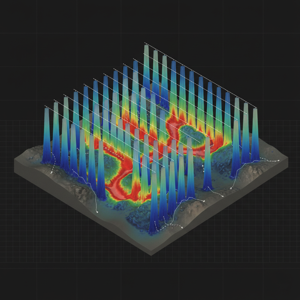
3D conductivity model
Stitched conductivity curtains beneath flight lines, isolating a productive freshwater aquifer between resistive basement and conductive overburden.
Structural recharge corridor
1D laterally-constrained inversion → 3D blocky model build → fault-corrected interpretation → drill-target ranking → water-chemistry prediction (TDS proxy).
From conductivity map to productive borehole.
Hydrogeological Briefing
Review existing wells, lithology, regional structure. Define target depth, expected water type, and drill-site constraints with client hydrogeologist.
Airborne EM Acquisition
Time-domain or frequency-domain EM flown over target area with co-acquired magnetic and gravity gradient data.
Inversion & Modelling
1D LCI followed by 3D blocky inversion. Conductivity model integrated with magnetic lineaments to identify fault-controlled aquifers.
Drill-Site Report
Ranked drill targets with predicted depth-to-water, aquifer thickness, salinity proxy, and structural rationale. Delivered to client drilling team.
What you receive.
3D conductivity model
Blocky 3D conductivity volume to depth-of-investigation. Voxel + GeoTIFF.
Conductivity-depth sections
2D vertical sections along survey lines + interpreted cross-sections.
Aquifer thickness map
Interpreted productive-horizon thickness with confidence bands.
Salinity proxy map
Conductivity-derived TDS estimate with calibration against existing wells.
Ranked drill targets
Priority-ranked sites with coordinates, predicted depth, and rationale.
Hydrogeological report
PDF report tying geophysics to regional hydrogeology + chain of custody.
Where this service is deployed.
Target your aquifer.
Share your AOI, target depth, and existing well data. We respond with a survey design, drill-target framework, and timeline within 48 hours.