مسوحات
فوق طيفية.
تصوير طيفي VNIR/SWIR لتصنيف معادن السطح، رسم خرائط إجهاد الغطاء النباتي، واكتشاف تسرب الهيدروكربون. أكثر من 270 نطاقاً طيفياً مُحَلّاً بدقة أرضية أقل من المتر.
- المستشعر
- VNIR-SWIR push-broom
- النطاقات الطيفية
- 270+
- النطاق الطيفي
- 400-2500 نانومتر
- الدقة الأرضية
- 0.5-2 م
- التغطية
- ~30 كم²/يوم
جيولوجيا طيفية من الجو.
معظم مواد السطح — الطين، أكاسيد الحديد، الكربونات، الكبريتات، الهيدروكسيدات، النباتات تحت الإجهاد، تسربات الهيدروكربون — تحمل توقيعات طيفية تشخيصية في نطاق VNIR و SWIR. التصوير فوق الطيفي يحل تلك التوقيعات بسرعة المسح.
أنظمة VNIR-SWIR push-broom لدينا تلتقط أكثر من 270 نطاقاً طيفياً متجاوراً بدقة أرضية أقل من المتر. تُطبَّق التصحيحات الجوية والهندسية ومطابقة المكتبة الطيفية حسب هدف المشروع — سواء كان ذلك رسم خرائط التحوير لاستكشاف المعادن، صحة الغطاء النباتي للأراضي الجافة، أو اكتشاف التسرب فوق ألعاب الهيدروكربون.
المخرج هو خريطة سطح مصنفة مرتبطة بنظام إحداثياتك، مدعومة بمكتبة عضو طيفي نهائي وثقة تصنيف لكل بكسل.
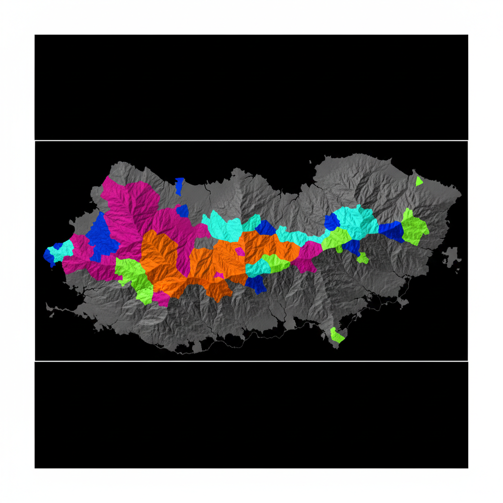
خريطة تحوير معادن
تصنيف VNIR-SWIR يفصل توقيعات الطين وأكسيد الحديد والكربونات — معلقة فوق ظل التضاريس للسياق الهيكلي.
خريطة مؤشر النبات
المعايرة الإشعاعية ← التصحيح الجوي (FLAASH/QUAC) ← التصحيح الهندسي ← الفصل الطيفي ← مطابقة مكتبة العضو النهائي ← تصنيف لكل بكسل + الثقة.
من الطيف إلى خريطة السطح المصنفة.
مكتبة طيفية للهدف
مكتبة العضو النهائي مُجمَّعة من مرجع USGS/ECOSTRESS + الأطياف الميدانية الخاصة بالمشروع حيثما توفرت.
التصوير الجوي
VNIR-SWIR push-broom يطير على طول الشرائط المخططة. زاوية الشمس والظروف الجوية مسجلة للتصحيح.
التصحيح الجوي والهندسي
تصحيح FLAASH/QUAC الجوي، تصحيح IGM الهندسي، والتصحيح الإملائي لنقاط التحكم.
التصنيف والتقرير
الفصل الطيفي، مطابقة المكتبة، التصنيف لكل بكسل مع الثقة. تقرير جيولوجي/زراعي يربط التصنيف بهدف الهدف.
ما تتلقاه.
خريطة سطح مصنفة
تصنيف لكل بكسل مع الثقة. GeoTIFF + ENVI.
مكتبة عضو طيفي نهائي
أطياف عضو نهائي خاصة بالمشروع مع البيانات الوصفية.
خرائط الوفرة
وفرة بكسل فرعي لكل عضو نهائي.
المؤشرات الطيفية
NDVI، NDWI، مؤشر الطين، نسبة أكسيد الحديد، إلخ.
فسيفساء بالألوان الحقيقية
ortho RGB مرجعي للتفسير البصري.
تقرير التفسير + سجل ضمان الجودة
تقرير PDF، معاملات التصحيح الجوي، مصفوفة ارتباك التصنيف.
أين تُنشر هذه الخدمة.
ارسم خريطة سطحك.
شارك منطقة اهتمامك وأعضائك النهائية المستهدفة. نرد باختيار النظام وخطة المعايرة والجدول الزمني خلال 48 ساعة.