مسوحات
مغناطيسية جوية.
رسم خرائط الشذوذ المغناطيسي الجوي عالي الدقة لاكتشاف الرواسب المعدنية وأنظمة الصدوع والهياكل الجيولوجية. مُنشر في الدرع العربي وهضبة نجد وممرات الاستكشاف الجافة حيث الوصول الأرضي محظور تشغيلياً.
- المستشعر
- مغناطيسي بخار السيزيوم
- الحساسية
- 0.001 نانوتسلا
- تباعد الخطوط
- 25-200 م
- الارتفاع عن الأرض
- 30-60 م فوق الأرض
- التغطية
- ~80 كم²/يوم
رسم خرائط تحت السطح من ارتفاع الطيران.
الدرع العربي هو أحد أكثر تضاريس القاعدة الواعدة في العالم — وأحد أصعبها وصولاً برياً. مسوحات المغناطيسية بالطائرات بدون طيار تسد تلك الفجوة، تحل الشذوذات في الارتفاع حيث الطرق المعتمدة على المركبات بطيئة أو مكلفة أو ببساطة غير ممكنة.
تلتقط منصة بخار السيزيوم لدينا شدة المجال المغناطيسي الكلي بحساسية 0.001 نانوتسلا. نُطيِّر شبكات ضيقة على ارتفاع منخفض، ثم نعالج البيانات عبر التصحيح اليومي، إزالة IGRF، الموازنة، والموازنة الدقيقة — قبل أن يحول فريق التفسير لدينا المجال المتبقي إلى نموذج هيكلي وصخري.
المخرج ليس بيانات خام. إنه منتج جيوفيزيائي مفسر: خرائط لتباينات القابلية المغناطيسية، خطوط هيكلية مشتقة، تقديرات العمق إلى المصدر، وأهداف حفر مُرتبة — جميعها تُسلَّم مع تتبع كامل لضمان وضبط الجودة.
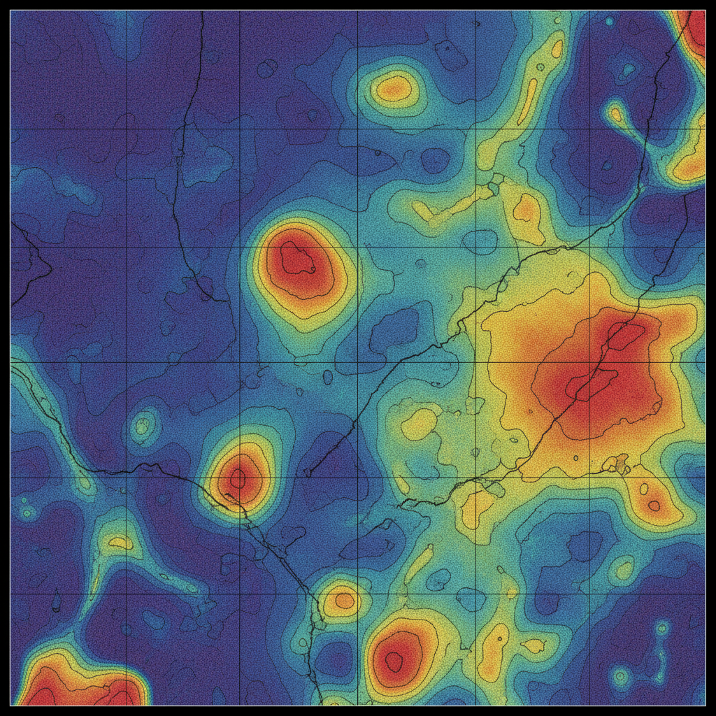
شبكة شذوذ مغناطيسي
TMI مُوازَن ومُوازَن دقيقاً مع خطوط كنتورية مغناطيسية — أساس التفسير الهيكلي ونمذجة العمق إلى المصدر.
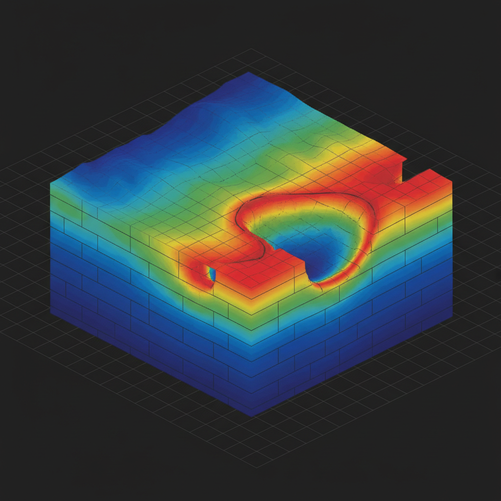
حجم القابلية
التصحيح اليومي ← إزالة IGRF ← الموازنة ← الموازنة الدقيقة ← RTP ← الإشارة التحليلية والمشتقات ← حلول عمق أويلر ← انعكاس قابلية ثلاثي الأبعاد.
من خطة الطيران إلى هدف الحفر.
تخطيط الطيران والمجال الجوي
تصميم الكتلة، اتجاه الخط، تصاريح GACA، واختيار المرجع الأرضي. تقييم مخاطر مفصل للممرات الصحراوية والنائية.
الاكتساب الجوي
مغناطيسي مثبت على طائرة بدون طيار يطير على طول شبكة مخططة مسبقاً. مرجع يومي مستمر في محطة القاعدة لتصحيح المجال الزمني.
المعالجة وإزالة الضوضاء
التصحيح اليومي، إزالة IGRF، الموازنة، الموازنة الدقيقة، RTP، ومشتقات الإشارة التحليلية. سجل المعالجة الكامل مؤرشف.
التفسير والتقرير
استخراج الخطوط الهيكلية، نمذجة العمق إلى المصدر، ترتيب أهداف الحفر. تقرير جيولوجي يُسلَّم لجيولوجيي العميل.
ما تتلقاه.
شبكة شدة المجال الكلي
مُوازَنة، مُوازَنة دقيقاً، مُصححة بـ IGRF. GeoTIFF + خام.
الإشارة التحليلية والمشتقات
المشتقات العمودية الأولى والثانية، مشتقة الإمالة، RTP.
خريطة الخطوط الهيكلية
صدوع متجهة، تلامسات، أسراب جدارية مع إحصائيات الاتجاه.
نموذج العمق إلى المصدر
حلول عمق أويلر / فيرنر مع نطاقات الثقة.
ترتيب أهداف الحفر
شذوذات مُرتبة بالأولوية مع المبرر والإحداثيات.
التقرير النهائي + سجل ضمان الجودة
تقرير PDF، سجل المعالجة، سجلات المعايرة، سلسلة الحيازة.
ارسم خريطة كتلتك.
شارك منطقة اهتمامك والعمق المستهدف. نرد بتباعد الخطوط والجدول الزمني والأسعار خلال 48 ساعة.