رسم خرائط
إشعاعية.
قياس طيف أشعة جاما لتصنيف صخور السطح ورسم خرائط التحوير وتحليل نسب U/Th/K. مقياس تشتت NaI ذو نافذة مستمرة يطير على ارتفاع منخفض لمسوحات مشعة عالية الدقة.
- الكاشف
- مقياس تشتت NaI(Tl) 4-8 لتر
- القنوات
- 256 (طيف مستمر)
- نطاق الطاقة
- 0-3 ميغا إلكترون فولت
- تباعد الخطوط
- 50-200 م
- التغطية
- ~70 كم²/يوم
كيمياء السطح على ارتفاع الطيران.
رسم الخرائط الإشعاعية يحل انبعاثات جاما الطبيعية للبوتاسيوم (K) والثوريوم (Th) واليورانيوم (U) — ثلاثة من أكثر العناصر تشخيصية لصخور السطح ومعادن التحوير وعمليات التجوية. التقنية سريعة وغير غازية وتعمل عبر طبقة الرغول الرقيقة وغطاء النباتات.
نظامنا الجوي يلتقط أطياف جاما المستمرة بـ 256 قناة على ارتفاع منخفض. تُصحَّح الأطياف لتخفيف الارتفاع، الرادون الجوي، والخلفية الكونية؛ ثم تُحوَّل إلى تركيزات أرضية ظاهرة لـ K/Th/U.
المخرج هو خريطة تركيبية ثلاثية K/Th/U بالإضافة إلى شبكات عناصر فردية — تُستخدم للتمييز الصخري ورسم خرائط التحوير وكطبقة مدخلات لتفسير الاستكشاف الأوسع.
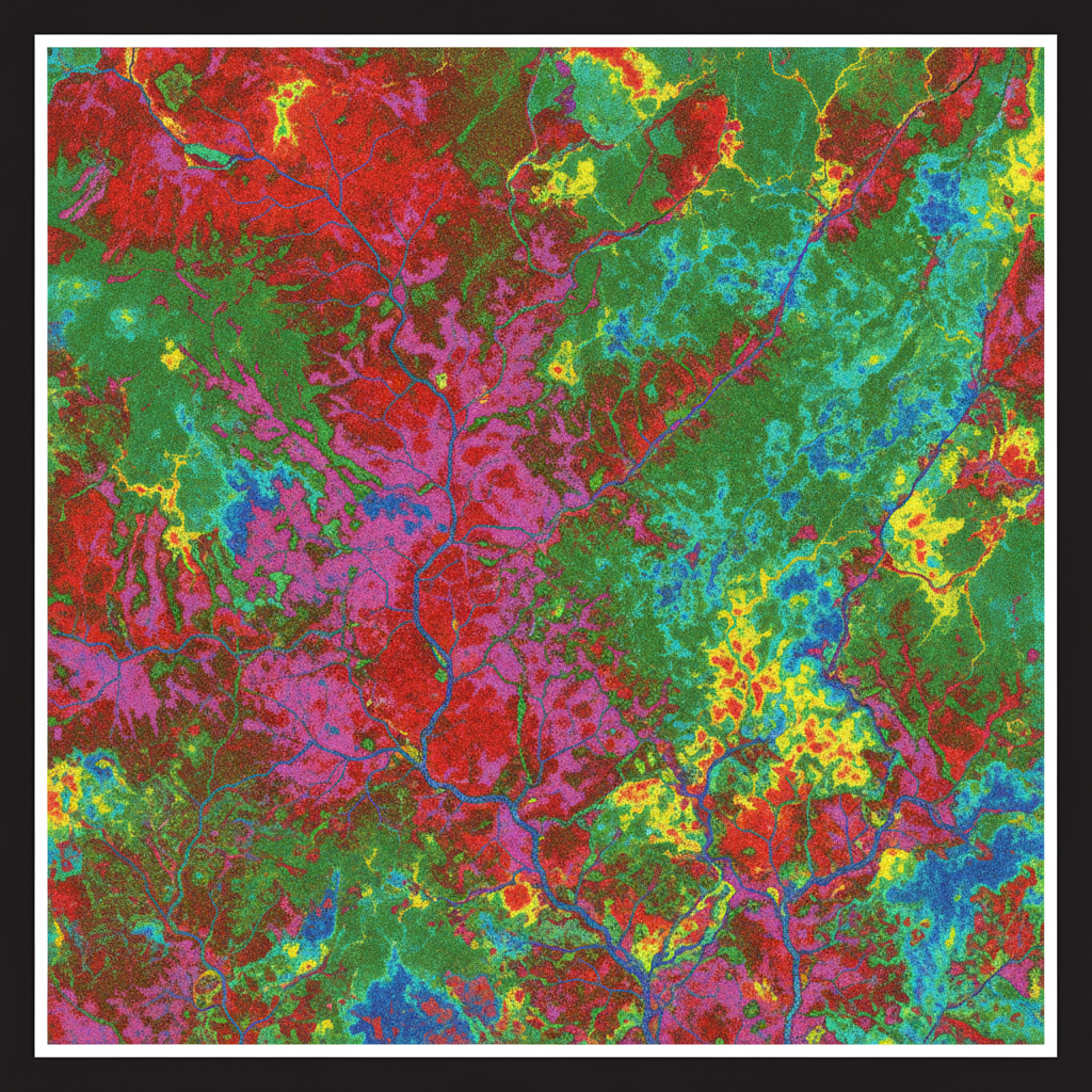
خريطة K-Th-U ثلاثية
تركيب RGB للتركيزات الأرضية للبوتاسيوم والثوريوم واليورانيوم — تشخيصي للصخور والتحوير عند السطح.
مؤشر التحوير
إزالة الكونية + الرادون ← تصحيح تخفيف الارتفاع ← إزالة النافذة ← التحويل إلى تركيز أرضي ظاهر ← تركيب RGB ثلاثي + شبكات نسب.
من عدد جاما إلى خريطة الصخور.
المعايرة وتصميم الكتلة
الكاشف مُعاير على وسادة معتمدة. تباعد الخطوط والارتفاع مضبوطان لمقياس الشذوذ المتوقع.
الاكتساب الجوي
طيران شبكة ضيقة على ارتفاع منخفض مع تسجيل طيف 256 قناة مستمر.
المعالجة الطيفية
إزالة خلفية الكونية والرادون، تصحيح تخفيف الارتفاع، تطبيق إزالة النافذة لاستخراج K/Th/U.
التفسير والتقرير
تركيب ثلاثي، تحليل النسب (Th/K، U/Th)، تصنيف الصخور، خريطة التحوير. التكامل مع السياق المغناطيسي للتفسير الكامل.
ما تتلقاه.
شبكات تركيز K, Th, U
ثلاث شبكات منفصلة في التركيز الأرضي الظاهر (%K, ppm Th, ppm U).
تركيب ثلاثي
تركيب RGB لـ K-Th-U للتفسير البصري.
شبكات النسب
نسب Th/K, U/Th, U/K للتمييز التحويري.
تصنيف الصخور
تصنيف مُشرف عليه مقابل جيولوجيا العميل.
خريطة مؤشر التحوير
مؤشر تحوير مشتق يُبرز المناطق الحرارية المائية.
التقرير النهائي + سجل ضمان الجودة
تقرير PDF، شهادات المعايرة، سجل المعالجة، سلسلة الحيازة.
أين تُنشر هذه الخدمة.
ارسم خريطة إشعاعك.
شارك كتلتك والهدف الجيولوجي. نرد بمواصفات الكاشف وتباعد الخطوط والجدول الزمني خلال 48 ساعة.